吉林省是农业大省,围绕黑土地农业生态监测需要,团队通过集成卫星遥感、航空遥感及地面农情物联网,研发了星空地一体化数字农业技术,服务于农作物的分类、出苗、长势、受灾、估产等立体监测及数字乡村建设。
该技术依托高分辨率对地观测系统吉林数据与应用中心平台作为卫星遥感数据保障,集成了国际领先的美国asd便携式光谱仪、美国head wall机载及地面两用成像光谱仪、无人机搭载多光谱成像仪和高光谱仪,以及植物物候相机、光合有效辐射、土壤温湿度等农情物联网等数据,结合农作物栽培试验,研发出系列农业遥感数据产品,包括农作物分类分布、农作物出苗和长势监测、主要农业灾害的预警和监测、农作物灾害估损和农作物产量估测等。
目前,该研究成果在吉林省、黑龙江、辽宁和内蒙等地区多年广泛应用,服务于吉林省政府农业种植结构调整及农业保险公司的估损及定损,为吉林省政府和相关职能部门提供决策支持,产生了显著社会及经济价值。
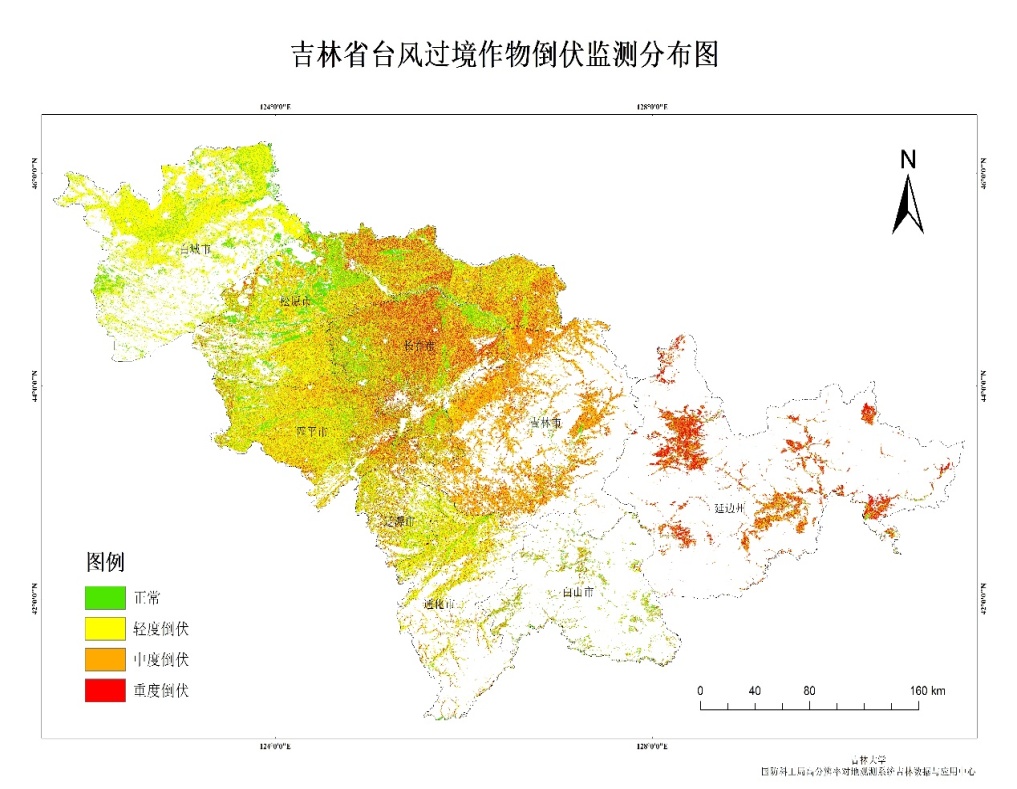
图1 2020年吉林省台风过境后玉米倒伏遥感监测
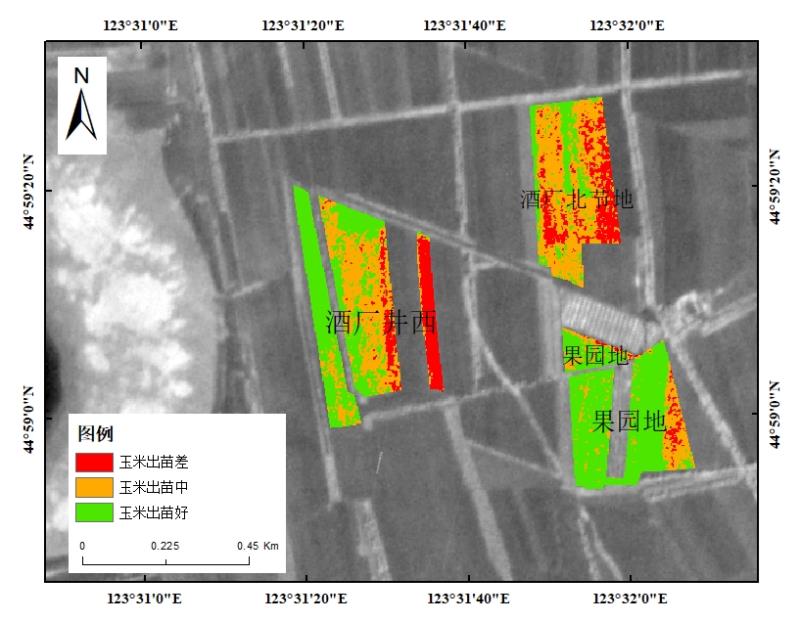
图2 地块级作物出苗分布图
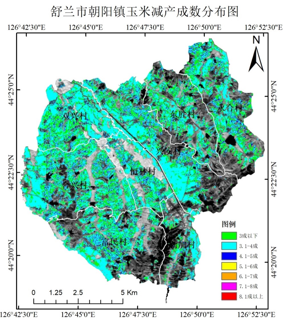
图3 镇级作物出苗分布图
上述研究成果发表在国际期刊《remote sensing》和《ieee transactions on geoscience and remote sensing》上。
(1).zhu;shengbo chen;yijing cao;zhengyuan xu;yan yu;cheng han [j].remote sensing 2021 vol.13 no.356 p356 2072-4292.
(2).xu xitong; chen shengbo; xu zhengyuan; yu yan; zhang sen; dai rui. exploring appropriate preprocessing techniques for hyperspectral soil organic matter content estimation in black soil area. [j]. remote sensing, 2020, vol. 12(22): 3765
(3).zhen zhijun; chen shengbo; qin wenhan; yan guangjian; gastellu-etchegorry jean-philippe; cao lisai; murefu mike; li jian; han bingbing.potentials and limits of vegetation indices with brdf signatures for soil-noise resistance and estimation of leaf area index.[j]. ieee transactions on geoscience and remote sensing, 2020, vol.58(7): 5092-5108
(4).yu yan; chen shengbo; qin wenhan; lutianqi; cao yijing. a semi-empirical chlorophyll-a retrieval algorithm considering the effects of sun glint, bottom reflectance, and non-algal particles in the optically shallow water zones of sanya bay using spot6 data. [j]. remote sensing, 2020, vol. 12(17): 2765
